

You’re not out of the woods yet. A powerful flood threat is looming over 35 million people across 13 states, stretching from Texas to the Carolinas, and you’re right in the crosshairs. On Thursday, a stalled cold front and tropical moisture will combine to unleash torrential rain and thunderstorms, putting you at risk of flash flooding. If you’re in southeastern Texas, southwestern Louisiana, or the mid-Atlantic, you need to be prepared for rainfall rates of up to 3 inches per hour and totals reaching 3-5 inches by the end of the week.
Key Takeaways:
- 35 million people affected: Across 13 states, spanning a 1,000-mile stretch from Texas to the Carolinas, face a dangerous flood threat on Thursday.
- Bull’s-eye for flooding: Southeastern Texas and southwestern Louisiana are at highest risk, with rainfall rates of up to 3 inches or more per hour expected.
- Flood Watches and Warnings: Issued across southeastern Texas, including Houston, and parts of Louisiana, with nearly 2 million people at risk of flooding.
- Mid-Atlantic also at risk: Heavy rain and flooding possible across the Carolinas, with Flood Watches posted in eastern North Carolina and South Carolina.
- Torrential rain and thunderstorms: Expected to continue pounding the southern US from Texas to the Carolinas over the next several days, with rainfall totals of up to 3-5 inches expected in some areas.
The Flood Threat
The danger of flooding is real, and it’s heading straight for you. With 35 million people across 13 states bracing for impact, the threat is far-reaching and potentially devastating.
Affected Areas
An enormous swath of the country, stretching over 1,000 miles from Texas to the Carolinas, is at risk of flooding on Thursday. You’re not alone if you’re in the bull’s-eye, which includes parts of southeastern Texas and southwestern Louisiana, where the rain is expected to be heaviest.
Weather Systems Converging
Converging weather systems are setting the stage for a perfect storm of flooding. Two powerful systems will combine to drench the region, bringing rainfall rates of up to 3 inches or more per hour.
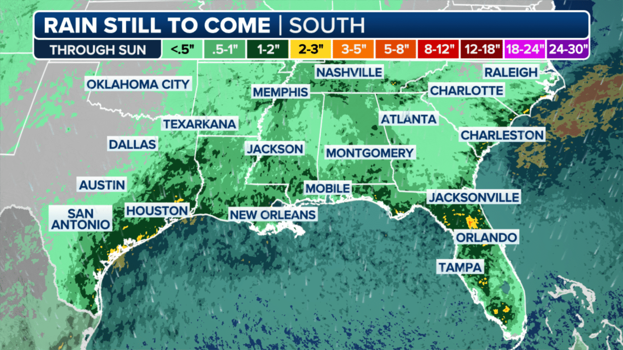
The FOX Forecast Center warns that slow-moving storms could slam Texas and Louisiana on Thursday, with torrential rain already falling in the morning and expected to continue into the afternoon. The highest rainfall totals are expected along the middle and upper Texas coasts, with totals reaching up to 3-5 inches by the end of the week. If you’re in this area, be prepared for flash flooding, as the likelihood of training storms is high.
Houston Under Flood Watch
It’s a dire situation in Houston, where you’re bracing for more rounds of heavy rain and thunderstorms. As a result, Flood Watches remain in effect, putting nearly 2 million people along the Texas and Louisiana coasts at risk of flooding.
Renewed Threat of Flooding
With the region already reeling from Hurricane Beryl, the combination of a stalled-out cold front and a surge of tropical moisture poses a renewed threat of flooding on Thursday.
Torrential Rain and Thunderstorms
Rainfall rates of up to 3 inches or more per hour are expected, with the highest rainfall totals predicted along the middle and upper Texas coasts, generally between Matagorda and Galveston bays.
Under the threat of torrential rain and thunderstorms, you can expect flash flooding to become a major concern. The FOX Forecast Center warns that the likelihood of training storms – those that repeatedly move over the same area – capable of up to 3 inches of rain or more per hour is high, making numerous reports of flash flooding likely.
The Bull’s-Eye for Flooding
All eyes are on the regions most prone to flooding as the storm systems converge.
Southeastern Texas and Southwestern Louisiana
Louisiana’s neighbors in southeastern Texas are bracing for impact, as the two regions face the highest risk of flooding due to the combined forces of the stalled cold front and tropical moisture.
Rainfall Rates of Up to 3 Inches Per Hour
An onslaught of heavy rain is expected, with rates reaching up to 3 inches per hour in some areas, leading to a high likelihood of flash flooding.
This intense rainfall will be fueled by training storms, which will repeatedly move over the same area, dumping massive amounts of water and exacerbating the flood risk. With rainfall totals of up to 3-5 inches expected along the middle and upper Texas coasts, the situation is precarious, and you need to be prepared for the worst.
Slow-Moving Storms and Flash Flooding
Not all storms are created equal, and the ones affecting the southern US this week are particularly concerning. Slow-moving storms can bring prolonged periods of heavy rain, leading to flash flooding and dangerous travel conditions.
Exclusive FOX Model Future track
Forecasting the future, our exclusive FOX Model Future track shows more rounds of torrential rain and thunderstorms pounding areas of the southern US from Texas to the Carolinas over the next several days, putting millions at risk of flooding.
Rounds of Torrential Rain and Thunderstorms
Modeling suggests that the region will see numerous rounds of heavy precipitation, with rainfall rates reaching up to 3 inches or more per hour in some areas.
This is particularly concerning, as the region has already seen significant rainfall in recent days, leaving the ground saturated and increasing the risk of flash flooding. You can expect the heavy rain to continue through the afternoon, with the highest rainfall totals expected along the middle and upper Texas coasts. Communities from Corpus Christi to Galveston and into Lake Charles, Louisiana, are at high risk of flooding, with nearly 2 million people under a Level 3 out of 4 risk of flooding.
Torrential Rain and Flash Flooding Risks
Unlike other weather systems, the combination of a stalled-out cold front and a surge of tropical moisture is expected to bring torrential rain and thunderstorms to the region, putting over 35 million people across 13 states at risk of flooding.
Highest Rainfall Totals Expected
The FOX Forecast Center predicts that the highest rainfall totals will occur along the middle and upper Texas coasts, generally between Matagorda and Galveston bays, with totals reaching up to 3-5 inches by the end of the week.
Conditions in the Atmosphere
Flash flooding risks are heightened due to the conditions in the atmosphere, which are conducive to training storms capable of dumping up to 3 inches of rain or more per hour.
Understanding the complexity of these atmospheric conditions is crucial in predicting the severity of the flooding threat. The likelihood of training storms is high enough in the region that numerous reports of flash flooding are likely, making it crucial for you to stay informed and take necessary precautions to ensure your safety.
Flood Watches and Warnings
After reviewing the latest forecast models, it’s clear that you’re facing a high risk of flooding on Thursday. The threat is real, and you need to take necessary precautions to ensure your safety.
NOAA’s Weather Prediction Center
Warnings have been issued by NOAA’s Weather Prediction Center, placing nearly 2 million people along the Texas and Louisiana coasts in a Level 3 out of 4 risk of flooding on Thursday. This means you can expect heavy rainfall rates of up to 3 inches or more per hour, leading to flash flooding in the region.
Communities at Risk
For those living in southeastern Texas and southwestern Louisiana, the threat of flooding is particularly high. You’re not alone – over 35 million people are facing this danger across 13 states.
Flood Watches and Warnings have been issued for cities including Houston, Rockport, Bay City, Port Arthur in Texas, and Lake Charles in Louisiana. If you’re living in these areas, make sure you’re prepared for the worst. Stock up on emergency supplies, stay informed about the latest forecast, and be ready to evacuate if necessary.
Mid-Atlantic Faces Flood Risk
Many areas in the mid-Atlantic region are bracing for heavy rain and potential flooding on Thursday, with you likely to be affected if you live in the Carolinas.
Heavy Rain and Flooding Possible
Rainfall totals of several inches are expected across the mid-Atlantic, with coastal areas likely to receive 3-5 inches through the end of the week. Locally higher amounts are possible, and you should be prepared for flooding in low-lying areas.
Flood Watches Posted
To ensure your safety, Flood Watches have been issued for much of eastern North Carolina and South Carolina, including major cities like Raleigh, Wilmington, Columbia, Myrtle Beach, and Charleston.
Possible flash flooding is a major concern, especially in areas with poor drainage. You should stay informed about the latest forecast and be prepared to take action if a Flood Warning is issued for your area.
To wrap up
Drawing together the threads of this weather report, you’re facing a dire flood threat if you’re among the 35 million people across 13 states. From Texas to the Carolinas, a 1,000-mile stretch of the US is bracing for impact. With rainfall rates reaching up to 3 inches per hour, your safety depends on staying informed and prepared. Stay ahead of the storm with the latest updates and take necessary precautions to protect yourself and your loved ones.