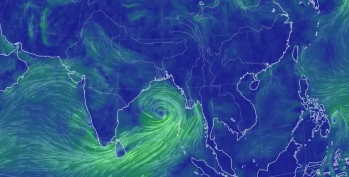
Cyclone Remal observed in the Bay of Bengal on Earth Nullschool at 9 am IST, May 24.
Cyclone could make landfall between Digha and Khulna on Bengal & Bangladesh coasts respectively between May 26 & May 27; Kolkata on orange alert
The looming threat of a cyclone at the end of May has returned to West Bengal.
As we approach the 15th anniversary of Cyclone Aila, the fourth of Cyclone Amphan, and the third anniversary of Cyclone Yaas, it is anticipated that a ‘very severe cyclone’ will impact the coastal regions of West Bengal and Bangladesh between the evening of May 26 and the morning of May 27, according to sources from the India Meteorological Department (IMD) who spoke to Down To Earth (DTE).
On May 23, the IMD officially forecasted that a ‘severe cyclone’ would form by the evening of May 26. However, a senior IMD official based in Delhi confirmed the likelihood of a very severe cyclone, with wind speeds ranging from approximately 125 to 135 kilometers per hour, striking the area.
Aila struck on May 25, 2009, with peak winds of 120 kmph. Yaas made its landfall on May 26, 2021, reaching top speeds of 140 kmph. Conversely, Amphan escalated into a super cyclone and became one of the most powerful tropical cyclones in the Bengal delta, striking land on May 20, 2020. These three cyclones inflicted significant damage in the Sundarbans and other regions of West Bengal.
The impending cyclone will be named ‘Remal’ if the depression strengthens into a cyclonic storm. It could affect the Sundarbans area if it makes landfall on the Indian coast during high tide.
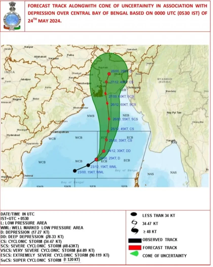
“It (low pressure area, the status on May 23) is very likely to continue to move north-eastwards and concentrate into a Depression over central parts of the Bay of Bengal by the morning of May 24, 2024. Thereafter, it is very likely to continue to move north-eastwards, intensifying further into a cyclonic storm over east-central Bay of Bengal by May 25 morning. Subsequently, it would move nearly northwards and reach near the Bangladesh and adjoining West Bengal coasts by May 26 evening as a severe cyclonic storm,” said a communiqué shared by Somnath Dutta.
“Kolkata is forecasted to experience significant rainfall between May 25 and 27,” Dutta informed this journalist. Notably, the IMD has announced an orange alert for May 26 and 27, predicting rainfall up to 20 centimetres in the city.
“Persisting on a nearly northward trajectory, it is highly probable that it will make landfall between the coasts of Bangladesh and West Bengal, specifically from Sagar Island to Khepupara, around midnight on May 26 as a severe cyclonic storm,” according to the official IMD statement released on the morning of May 24.
Also Read: Where will Cyclone Remal Land according to Weather Agencies

Source : IMD
Where will it strike?
Experts from the cyclone unit at IMD Delhi have indicated that the cyclone might escalate to a very severe level. “It’s premature to confirm, but the system is anticipated to develop into a very severe cyclone, with wind speeds ranging from 125 to 135 kmph,” stated a senior scientist from IMD, adding that the landfall is predicted to occur between the evening of May 26 and the morning of May 27.
“It’s currently too soon to determine the precise landfall location, but it could impact coastal regions near Digha or the Sundarbans in West Bengal and Khulna in Bangladesh,” the expert remarked, highlighting that there is a higher likelihood of the cyclone striking the coast of Bangladesh.
A senior official from West Bengal’s disaster management department mentioned that they are closely monitoring the cyclone’s progress and are prepared to act swiftly if it makes landfall on the West Bengal coast.
“The weather system’s path is changing rapidly. Initially, it was heading towards Visakhapatnam, then it shifted towards Bhubaneswar, and now it’s moving towards West Bengal and Bangladesh. The chief secretary has already convened a meeting and alerted all relevant stakeholders,” the official stated.
The Sundarbans: vast mangrove forest located in the delta region of the Padma, Meghna, and Brahmaputra River basins.
Specialists warn that the cyclone could inflict some damage on the Sundarbans if it makes landfall on the Indian coast and coincides with a high tide.
According to data from Kolkata Port Trust (KPT), high tides are predicted around 11 pm on the night of May 26 and approximately 11 am on the morning of May 27, with the peak tide expected to reach about 5 meters.
“If the cyclone’s landfall aligns perfectly with the high tide, the water level could rise by several feet. However, only partial damage is likely, as the high tide level is not particularly high during this season,” explained a KPT expert.
“We witnessed during Aila and partially during Amphan how cyclones combined with high tides led to chaos. Therefore, we are quite worried,” said Animesh Mandal from Gosaba island in the Sundarbans.
“Given that the sea near the West Bengal coast is relatively shallow, the cyclonic winds amplify water surges, affecting embankments,” noted another expert from IMD, who added that the monsoon system might also play a role in influencing the cyclone.


