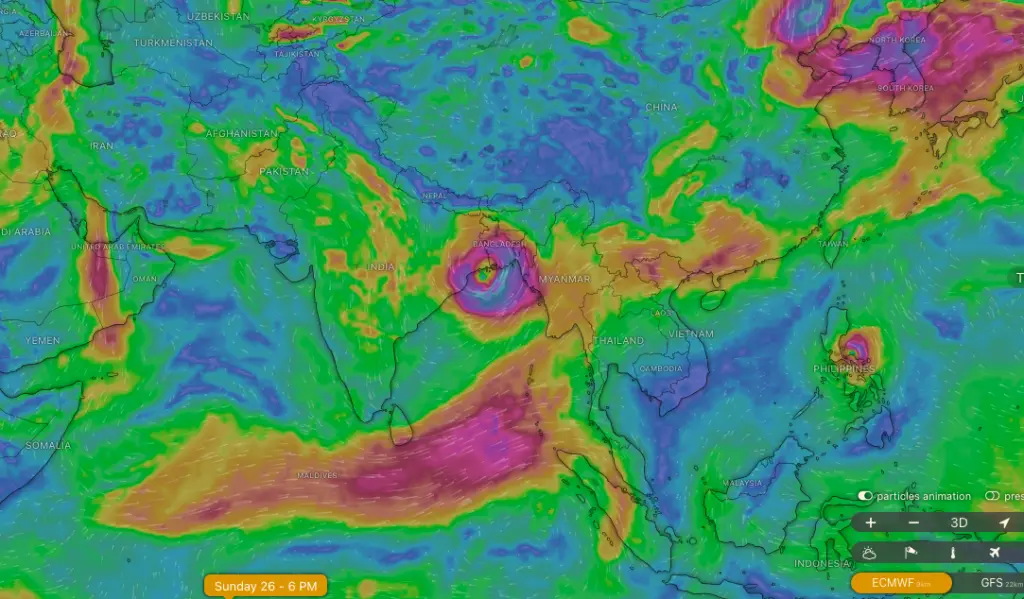
An image capture from Windy.com illustrating the potential landfall of Remal in Bengal.
Cyclone Remal is expected to develop over the east-central Bay of Bengal in the early hours of May 25 and may intensify into a severe cyclone by the morning of May 26. This storm could exhibit some unpredictable behaviors, particularly concerning its path and landfall, which would keep the India Meteorological Department (IMD) and the relevant state authorities vigilant.
According to the latest update from the IMD, a low-pressure area that has formed in the southern Bay of Bengal is likely to intensify into a depression with wind speeds ranging from 40 to 50 kilometers per hour by the morning of May 24. It may further escalate into a deep depression with wind speeds between 50 and 60 kilometers per hour on the same day, and subsequently evolve into a cyclone with wind speeds of 60 to 70 kilometers per hour by the following morning, generally moving in a northeastern direction.
Once Cyclone Remal forms, it is anticipated to turn northward, accumulating more moisture and increasing wind speeds. It is projected to approach the West Bengal and Bangladesh coasts as a severe cyclone with wind speeds up to 120 kilometers per hour, as per IMD predictions.
The weather forecasting platform Windy.com presents two potential tracks for Cyclone Remal based on different data sets.
Drawing on meteorological and climate modeling data from the European Centre for Medium-Range Weather Forecasts (ECMWF), Windy indicates that the cyclonic system will be relatively weak, follow a northerly path, and make landfall along the coast of West Bengal, targeting the highly vulnerable Sundarbans delta in the late evening hours of May 26.

A screenshot from Windy.com depicting the potential landfall of Remal in Odisha.
Conversely, Windy’s analysis using the United States (US) Global Forecasting System (GFS) data suggests that the cyclone is veering sharply westward and is projected to make landfall along the Odisha coast between Puri and Paradip on the morning of May 26.
The latest report from the US Navy’s Joint Typhoon Warning Centre (JTWC) underscores the favorable conditions for cyclone formation, such as warm sea surface temperatures ranging from 30-31°C and moderate vertical wind shear. However, the JTWC has yet to detail the precise path of cyclone Remal or provide information regarding its expected wind speeds.
“The forecast models have so far provided varying predictions regarding the trajectory and strength of Cyclone Remal,” reports The Weather Channel (TWC) in its latest update on the cyclone.
TWC also mentions that “The Global Forecast System (GFS) suggests a possible intensification into either a Severe Cyclonic Storm (SCS) or Very Severe Cyclonic Storm (VSCS) as it moves northwest towards eastern India.” Conversely, the ECMWF “predicts a less intense system, likely staying as a depression due to upper cold air currents, and heading northward towards Bangladesh or northeastern India,” as stated by TWC.
Recent tropical storms across various ocean regions have demonstrated highly unpredictable behavior, emphasizing the need for improved early warning systems to alert at-risk communities in advance.
The IMD has forecasted intense rainfall for West Bengal, Odisha, Mizoram, Tripura, and southern Manipur on May 26 and May 27.
Both national and international meteorological organizations, particularly the IMD, along with the state governments of Odisha, West Bengal, and the northeastern states of Mizoram, Manipur, and Tripura, will remain vigilant and monitor the cyclonic activity closely as it approaches landfall over the coming two days.


